
And also the northernmost point within the proper territory of Europe.
If I were to tell a random person on the street today that the North Cape isn’t actually the northernmost point of Europe—or even Norway—they’d likely find it hard to believe. Yet, this is the truth. The North Cape’s status as the northernmost point is less about geography and more about marketing. Its fame has been carefully crafted, and as a result, many people associate it with being the northernmost point of Europe, even though that’s not entirely accurate. But there’s more to the story.
For centuries, the rugged and remote Arctic has captivated human imagination. The first recorded visit to the North Cape by a European was made by Richard Chancellor, an English navigator, in 1553. He was part of an expedition tasked with finding a sea route to Russia and Asia via the Arctic. However, the indigenous Sámi people had been living in the region long before any European explorers set foot there. Written references to North Cape appear in Viking sagas, though it’s unclear whether these accounts specifically referred to the cape.
Explorers like Chancellor in the late 16th century believed that the North Cape marked the northernmost point of mainland Europe. Due to its prominence as a natural landmark, it became recognized as the northernmost point in Europe—even though it wasn’t. Because it was the farthest northern point they encountered, North Cape solidified its place in history as the northernmost point of the European mainland.
Fast forward to the 20th century, and as Arctic tourism began to grow, North Cape was heavily marketed, particularly as a destination for tourists eager to visit the “end of the world.” Its dramatic cliffs, unique location, and breathtaking views made it an ideal tourist hotspot. Today, despite the geographical inaccuracy, North Cape remains synonymous with the northernmost point of Europe, largely due to the power of strategic marketing.
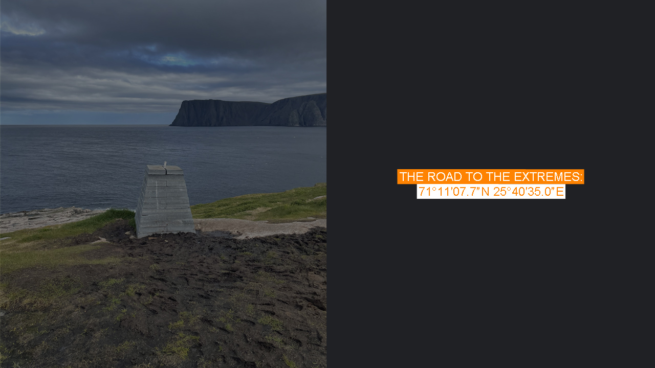
But the explorers weren’t entirely wrong when they declared North Cape the northernmost point. Knivskjellodden, located just 1.5 kilometers west of North Cape, extends 1,450 meters farther north. Knivskjellodden sits at 71° 11′ 08″ N, while North Cape is positioned at 71° 10′ 21″ N. So, while the difference in latitude is minimal (just under a minute of latitude), Knivskjellodden is technically the northernmost point within the proper territory of Norway and Europe. It’s also worth noting that both the North Cape and Knivskjellodden are located on Magerøya Island, while the Kinnarodden on the Nordkinn Peninsula is the northernmost point on the mainland.
The day before, I had returned from conquering the Kinnarodden hike, and what better way to continue than heading to Knivskjellodden to tick off both the northernmost points of Europe and mainland? The distance, as the crow flies, is only about 80 kilometers, but by car, it’s around 400 kilometers and a six-hour drive without stops. The drive itself is spectacular, with scenic fjord landscapes all around.
After spending the night camping near the E69 road that leads to North Cape and Knivskjellodden, it was time for the hike. It’s funny—on my way toward Knivskjellodden, I passed three motorhomes with Spanish plates, stranded in the middle of nowhere, driving at half the speed limit for God knows how many kilometers on a winding road. When heading to the Knivskjellodden parking lot, the same motorhomes were still causing a traffic jam, this time climbing a hill at a snail’s pace.
The parking lot for the Knivskjellodden hike is located 6 kilometers before the North Cape, and it’s hard to miss—it’s clearly marked on maps. I decided to take it easy, arriving at the parking area just after noon. Even though it’s relatively large, it was completely full, but I managed to squeeze my car in.
The hike is around 18 kilometers round-trip. The day’s highs were expected to be around 15°C, with the sun peeking out intermittently. It seemed I was going to be relatively lucky with the weather, but, as we know, it can change unpredictably. Some people say it’s an easy hike, while others find it more demanding—it’s all about perspective. I’d describe it as this: it’s not a leisurely walk; it’s certainly more than your average stroll with a dog. This is partly due to the length of the hike, but also because some sections involve challenging terrain. Then again, for Norwegians, it might just be a quick jog, I thought to myself, as a young woman passed me by, running.
From the parking lot, the path gradually ascends—not steeply at all, but enough to create some anticipation, as the view hasn’t really opened up yet. The first few hundred meters aren’t marked the best, but there’s a clear path, and it isn’t long before the red “T” trail markers start guiding the way. The only real hazard on this trail are the loose stones that could twist your ankle if you’re not careful.
The trail continues relatively flat for a while, heading west with some small ascents and descents that temporarily block the view. Eventually, around a small mountain lake, the landscape opens up, and on a clear day, you can see across the peninsula to the next fjord. Not long after, the trail begins turning northward. The descent is only about 300 meters, and while the terrain isn’t particularly steep, the ups and downs still block the view until it becomes clear the trail is leading toward a bay. You almost expect that to be the final destination. But no, the trail continues north of the bay, heading toward the tip of the peninsula. Just before the finish line comes the steepest descent, and you think, “This has to be the northernmost point,” but once again, the trail deceives you. There’s still another 1.5 kilometers to go. Most of this is along a cliff that slopes downward. Some sections are a bit slippery, so it’s important to stay focused to avoid injury.
The “fake” northernmost point, North Cape, remains visible on the right as you hike the final stretch. On this clear day, I almost feel sorry for all the tourists happily at North Cape, believing they’ve reached the northernmost point just by driving there. Someone should tell them—getting there requires a bit more effort than that.
This time, there was no moment of relief or tears of joy upon reaching the northernmost point. I must admit, though, a slight skepticism lingered—was this really it? The trail had deceived me more than once already, and I couldn’t help but wonder what lay beyond the hill. But then again, it’s always like that, isn’t it? So, I focused on exploring the lighthouse, making sure I had truly set foot on the northernmost soil.
I took the necessary photos and sat down by the postal box, where a guestbook and the monument for the northernmost point are located. I took my time, reflecting on the vastness of the ocean before me. Suddenly, I flinched and looked around at some fellow hikers who were also snacking. No one else seemed to notice what I saw. I quickly grabbed my phone, trying to capture it, but every time I was about to take a picture, the dolphin appeared elsewhere. It became a game of cat and mouse—each time I missed it, the dolphin seemed to vanish before I could get a photo. I tried filming instead, but the dolphin seemed to know what I was up to. Meanwhile, I also spotted a smaller species of whale.
After a while, I decided to head back. On the way down, someone asked me if there had been any whales spotted that day, and I told them to keep their eyes peeled.
The return hike felt a bit more challenging. Maybe it was because there was more ascent than descent, or because the sun had made the weather warmer, or perhaps because I’d already covered so many kilometers. But there was really nothing to complain about. At one point, I decided to take my shirt off and hike shirtless, which helped a bit.
I completed the hike in under six hours, but the 50 kilometers through the wilderness of Kinnarodden had inevitably taken a toll on my legs. When I finally spotted the car, it was a relief to know that I’d now conquered Knivskjellodden too. But nothing comes without a price. Immediately after finishing the hike, I decided it was best to head south, away from Magerøya—by the way, Magerøya means “Meagre Island” in English. I pulled off the road at a scenic photo spot, left my sunglasses on top of the car, and went to take some pictures. Then, I drove off and only realized later that I had left the sunglasses behind. I had to drive 30 minutes back to see if they were still there. After a bit of searching, I had to admit defeat and accept that they were gone.