France is the largest country in the European Union, and only Russia and Ukraine surpass it in size on the European continent. To give some perspective, the straight-line distance from the westernmost point near Brest to the easternmost near Lauterbourg is roughly 1,000 kilometers — and a bit less, 962 kilometers, from the southernmost to the northernmost.
My first extreme point in France had been the northernmost one on the Belgian border a few months earlier, and now it was time for the easternmost — right on the German border, where the line forms a narrow spike on the map.
If things had gone more smoothly in Luxembourg, I would have already visited this place on my way to France’s northernmost point. But now I was heading there a day older and hopefully a day wiser. The tank was full, and I’d even found an ALDI next to the gas station, so at least I had something resembling lunch.
I was in Donaueschingen, Germany, and quite excited for another drive through the Schwarzwald. This time, the drive wasn’t too long — only a couple of hours on the road. I had spent most of the day visiting the northernmost point of Switzerland, and now I was heading back along the same route I’d taken the day before. The original plan had been to make this visit while driving south, but it had gotten dark too early. There was no chance of seeing anything by then, so I just continued to the hotel I’d prebooked earlier, thinking things would work out a bit differently.
The autumn colors were spectacular — gold, amber, and red — and the timing was perfect. No rain in the forest, though when I joined the autobahn 5 toward Karlsruhe, the showers began.
My plan was to approach the point from the south, following the river Rhine for the last couple of kilometers. There’s a huge industrial area nearby — lubricant and chemical factories right next to the river. But Waze had other ideas and sent me first through the French town of Lauterbourg and then the German town of Berg. I didn’t even notice crossing the border at first, until I saw a German police car parked at a roundabout. That’s when I realized my plan to avoid any more border crossings that day had failed.
I was back in Germany.
And I wasn’t even sure if the point could be reached from this side, since a small river, the Alte Lauter, forms the border before flowing into the Rhine. From Berg, the road continued as a surprisingly busy country road. Just after the town, by the railroad, a tall man stood by the roadside, staring directly at my car. When I glanced in the rearview mirror, he was still staring — and kept staring until I disappeared around the corner.
By pure accident, I managed to stop at exactly the right spot. I had pulled over to check the map, thinking I might need to drive around to the other side of Lauterbourg. The small road ahead didn’t seem to lead anywhere — or at least not anywhere I was allowed to go, since there was a “no motor vehicles” sign. According to the map, I was close to the border. I reversed a little and noticed another car parked just behind the trees, before the sign. I decided to leave my car there and continue on foot.
It was almost a miracle that it wasn’t raining yet. The clouds were heavy and dark, but I decided to go without a jacket. When the sun peeked through, it was even a bit warm. On the French side lies the Lauterbourg Managed Biological Reserve — 57 hectares of untouched forest. It feels strange that such wilderness sits right next to a massive industrial zone.
There weren’t many people around. It was about 4 p.m., and I imagine the path is mostly used by local joggers and cyclists. My earlier concern about the bridge was unnecessary — 400 meters from the parking lot I was already at the border, in France. The trickiest part was descending from the road down to the Rhine. The grass slope was wet and slippery, and my shoes had completely slick soles. A couple of steps in, I lost traction. Somehow, miraculously, I managed to stay upright, though I had to twist my arm into an unnatural position to keep my balance. It hurt for a moment, but not enough to remember later.
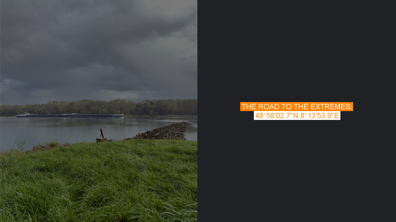
There it was — the Rhine.
In front of me stood a concrete marker with the number 352 on it, but the actual easternmost point was a bit further left, hidden behind trees. Across the narrow Alte Lauter — still on the German side, though not across the Rhine itself — a man was fishing, and beside him sat a woman. They had their car parked nearby, though I had no idea how they’d managed that legally.
I felt a little awkward taking selfies under the watchful eye of the woman. The fisherman didn’t seem to care, but she sat there, staring, as if guarding the border herself. I took a few photos and noticed a barge approaching from the north — from the German direction. I decided to wait; it would make the perfect background. But just as the barge aligned with my lens, the rain began. I took one quick shot, said goodbye to the place, and climbed back up the hill carefully — again managing not to fall.
My mission was nearly complete. This was the only place I had planned to visit besides the remaining extreme points of the Benelux countries. Why? Well, from looking at the map, it made sense — the easternmost point is far from the others, and I doubted I’d pass this way again anytime soon.
Now I just needed to decide where to stay for the night. I wanted somewhere nearby, but not too close. Sitting in the car, I browsed accommodation options when I saw the owner of the other parked car return — walking his dog, a German shepherd that looked exactly like Commissar Rex. That made sense — I was in Germany, after all.
Finally, I decided to drive to Contrexéville for the night. On my way back through Berg, I noticed that the same man who had been staring at me earlier was still standing in exactly the same spot, motionless. Whether he was curious about me, the car, or the Dutch plates, I’ll never know. With that thought lingering, I headed toward Contrexéville, hoping to make it as far as possible before sunset.